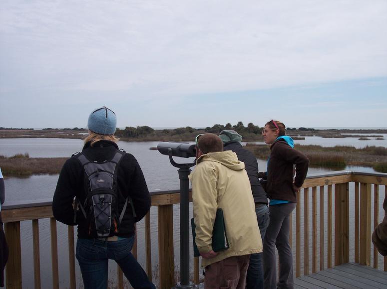
I was recently asked to give a presentation to the staff of Coastal Expeditions at the Dominick House on Bull Island. A number of these staff had just started work for their role as guides and naturalists, and the three days of training was planned to give them a strong background in interpretation. A number of presentations focused on natural history, but I was charged to focus on the human history of Bull Island and the larger Cape Romain area. There were some very important events I made sure to cover – the encounter between the Native American Sewees with the colonists off the ship Carolina on the Northeast Point on March 15, 1670; the live oaking industry on the island begun during the ownership of Thomas Shubrick, Jr; viewing Bull Island as plantation; the building of impoundments particularly during the tenure of the last private owner, Gayer Dominick, and then later in the late 1930’s by the CCC for the construction of the island’s largest impoundment, Jacks Creek. On the afternoon following my morning presentation, the group traveled around the island, and took a look at Jacks Creek from the top of the new observation tower.
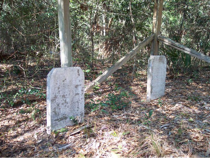
One history I wanted to share with this Coastal Expeditions group was of a Lowcountry family having strong ties to Bull Island through family members who grew up here – the Magwoods. The Magwoods have made an impact through their commercial fishing efforts, particularly in shrimping and oystering. Robert and Susan Magwood owned part of Bull Island, and Robert’s brother James Elliott also lived here. James’ son Clarence would grow up on the island, and built and lived in a homestead prior to having to move off to Little Bulls Island during Dominick’s tenure. Clarence’s first wife, Bessie Viola, and his father James Elliott, both rest in peace in a small graveyard on Bull Island.
Clarence’s son Andrew shared his family history with me, and informed me that the remains of his father’s home were still present on the island. He directed me to the location, but my initial attempt (described in Exploring Bull Island) was not fruitful.
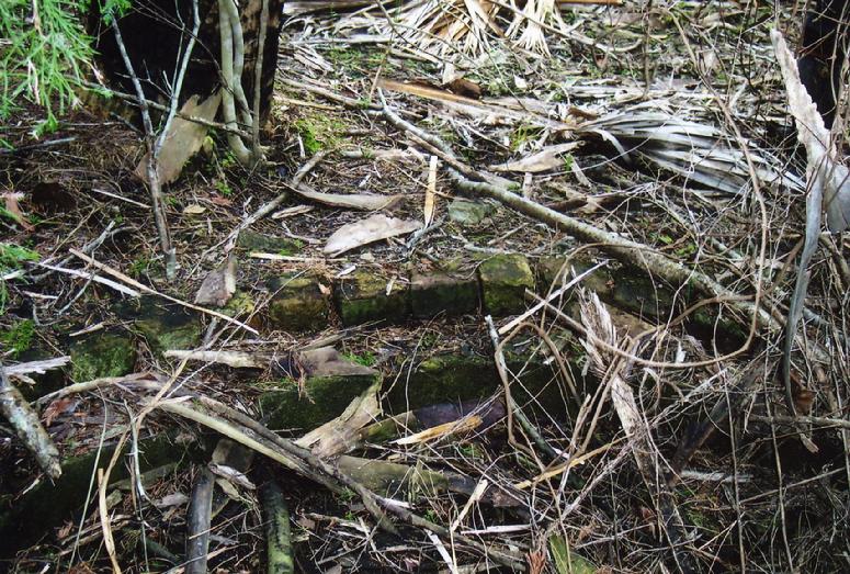
Andrew Magwood offered to take me over to find the remains of the homestead himself, so on a cold winter’s day in 2006 we bundled up and rode over in his skiff, landing on the island’s backside near the southern end. After tromping around for about 45 minutes, we hit pay dirt when he located one of the old house pilings.
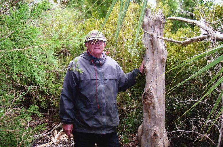
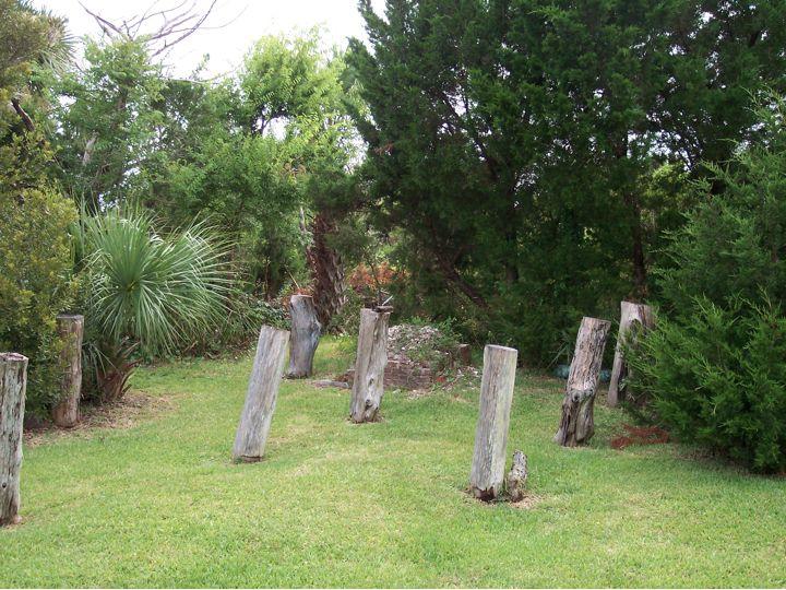
This existing piling was from a cedar tree, and reminded me of the cedar pilings left standing on Little Bulls Island. The house built on those pilings on the little island in Price’s Inlet had been swept clear during Hurricane Hugo in 1989.
In addition to the lone piling we also found other evidence of the homestead, most notably the remains of a brick cistern.
I also shared with the Coastal Expeditions group about a drama that occurred in Price’s Inlet in 1955 involving Clarence’s second wife Ethel, and his son Earl. Here is the story, excerpted from Exploring Bull Island.
A high drama played out in Price Inlet on a July day in 1955. The Magwood family lived on Little Bull’s Island at this inlet, and on this day the head of the household, Clarence, had gone to the mainland for supplies. Left on the island were his wife, Ethel, and two of their children, Earl, thirteen, and Mary, eight. Earl had gone to check on a bateau he had used as a float for a shark set line. He found the boat submerged and was not able to haul up the anchor alone. He sought help from his mother, and they returned in another bateau with an outboard engine. They both went to the bow to try and haul up the anchor, but water came over the bow quickly. Before they knew it the boat had swamped, sunk to the bottom with the weight of the outboard and left them on the surface on a fast-ebbing tide similar to my outgoing tide today. Fortunately, an oar surfaced for them to grab, as Ethel was a non-swimmer. Earl held on to his mother and the oar as the tide took them out toward the ocean. She told him several times to just save himself and let her go but he refused. After some time they found themselves on one of the sandbars in the inlet, most likely the southwest channel bar. Though able to stand they were still separated from Capers Island by a deep channel. After resting, Earl was able to propel his mother holding on to the oar across this channel to the beach of Capers, and from here they walked around to Price Inlet. But a water obstacle still separated them from their home, the deep tidal waterway Schooner Creek. Ethel told Earl she could not go back in the water again so he swam the creek, slogged across the marsh and made it to their island home. He grabbed another bateau with a motor and returned to the inlet to pick up his mother. Ethel had been very concerned that her daughter Mary was left alone at home. The young girl knew something was terribly wrong when her mother and Earl were gone for so long, so she maintained a vigil in front of a painting of the Last Supper, praying for her mother and brother. When Ethel ran into her home on her return, she found Mary asleep.
I had wanted to get back out to visit this homestead again, but the conditions had not been conducive for a sail out to the south end. On my Sunday morning run on the last day of February, and stopping off at the Romain Retreat landing, I noticed the tide was high, and there was already some west wind. It was a beautiful morning after a cold night, and the opportunity to head out to the south end of the island via Price’s Creek and inlet on the outgoing tide, and return with the incoming tide was inviting. There was also the opportunity to walk off the beaten path during winter before the appearance of ticks and moccasins. So I cast off Kingfisher, beating both the low tide at the landing and a large barge approaching from the south, and began the reach south down the Intracoastal Waterway (ICW). Approaching Garris Landing there were some bumps along the marsh side of the ICW that seemed out of place, and definitely too big to be cormorants. As I approached I realized that it was a group of ten kayakers paddling also to the south. Finally coming up with them and speaking I found they were also heading out to Price’s Inlet with a plan to land on Capers Island. As I sailed past, they warned me of a large barge approaching: an Army Corps of Engineers barge with crane, and towing a long stretch of dredge pipe behind it. The image astern of the kayakers passing by this huge floating works was striking.
After making the entrance to Price’s, I bore off and ran downwind with the strong push of the outgoing tide, winding through the turns of the creek until the open stretch toward the inlet and the south end of Bull appeared. Having landed here before, I dropped sail and easily came up on the sandy landing. This spot was even better than past trips in coming ashore, with a steep drop-off and an absence of oysters that I recalled from past trips. I made Kingfisher fast to an iron spike higher up on the shore with my towline. Stopping for a snack, I watched the kayakers slowly coming down, and passing by Little Bull’s Island on their way toward their destination further east.
Setting off along the southwestern part of the island, arcing toward the mainland, I was reminded how this landing spot and high ground would have been a natural overnight stopping point along the Inland Passage. I recalled how Nathaniel Bishop on his paper canoe voyage in 1875 spent the night here in a house with a young fisherman in “the employ of Mr. Magwood”. I am sure many others camped along here in the past. The remains of this sand spit are now covered with cedars along with some spreading live oaks. Walking on the edge of the marsh, beautiful pristine wildlife paths led me along the way, occasionally dropping down into groves of needlerush parted by these trails of raccoon and deer.
I anticipated finding the homestead, but soon realized it would not be easy. The subtropical forest dominated with palmettos is initially narrow between the sandy road and the marsh. Looking to cut back to the marsh, I came across a wetland in my path, and in trying to skirt it stepped in to the water, and felt the cold water infiltrate into my neoprene sock. Soon the other foot was wet, so I began to wade across, ready to do what was necessary in getting on track with this exploration. I reached the edge of the marsh on the large cove on this western side of the island where the power poles stretch across to supply power to the Dominick House and maintenance facilities of Bull Island. I looked for a landmark where Andrew Magwood and I cut across walking into the forest, but my recall was lacking. I blindly struck across, bushwhacking through the thicket on the marsh’s edge until reaching the higher ground. It was a palmetto jungle, clogged with vines and shrubs. In beginning the search, I looked for any familiar places, but on the walk often found I was back on the road.
After about an hour, I gave up, headed to the road, and walked back to the island’s end. Disappointed yes, but also reassured that this aspect of the island’s cultural heritage was safe, and further, that the island most assuredly harbored other secrets of its people. Though I was facing a sail against the wind back to the ICW, the turn of the tide pushed us along to windward, and helped once in the waterway on the long port tack home.
Mr.Raynor,I have delighted in reading your book and blogs.I was able to visit bull island in 2010;what an experience! Have you any idea where Thomas Shubrick et.al.might have lived when on the island? As you relate in your book there was a huge crew there in the early 1800s,and there are claims by Fenimore Cooper that my forebear,John Templar Shubrick, was born there Thank you for your attention,Jim Kothe
James – I understand that you and other family members visited the island, and your forbear was Thomas Shubrick. The stories of Thomas and his sons were fascinating to me when researching Exploring Bull Island. Alas, I never saw a plat with any residence for Shubrick, but if there was one I would speculate it would be in the vicinity of the current Dominick House. I continue to be a student of the island, and if your family has any of his papers in your possession I would be most interested.