It was a glorious morning when we embarked on our journey over to Bull Island for an all day hike, and a path I had not previously taken. Our hiking group of thirteen would disembark on the south end of Bull Island after our ferry journey south on the Intracoastal Waterway and through Price’s Creek to Price’s Inlet. We were piloted by Coastal Expedition’s chief, Chris Crolley, and his trained eye picked out a peregrine falcon just after hitting the ICW. The passing of wet weather the previous days, helping to fuel a nor’easter and blizzard up the coast, had left us with high pressure, and a pristine atmosphere for viewing faraway vistas. I felt it would be an eagle day, and in fact we had three sightings before even hitting the inlet landing. The plan of our walk was facilitated by the drop on the southern end, and the later pickup from the public dock. This beach landing only happened through the skill of Captain Chris, who knows these waters and shores intimately. With the tide ripping out, he still made the landing and positioned the gangplank so no one needed to wade to shore. The sand was very soft as we sunk up to our ankles, and we watched as Chris expertly made it off on the ebbing tide.
Ahead lay our walk (see map) – a stretch of seven miles of shoreline past the Boneyard to the Northeast Point. As we rounded the point away from the inlet to the Atlantic Ocean beach we viewed the curving coast all the way to the Boneyard. To the south the high rises and other structures on Isle of Palms were as sharply resolved by eye as it seemed possible at this distance. Seven miles of beach held the wonders of beach combing, and the shells did not disappoint. 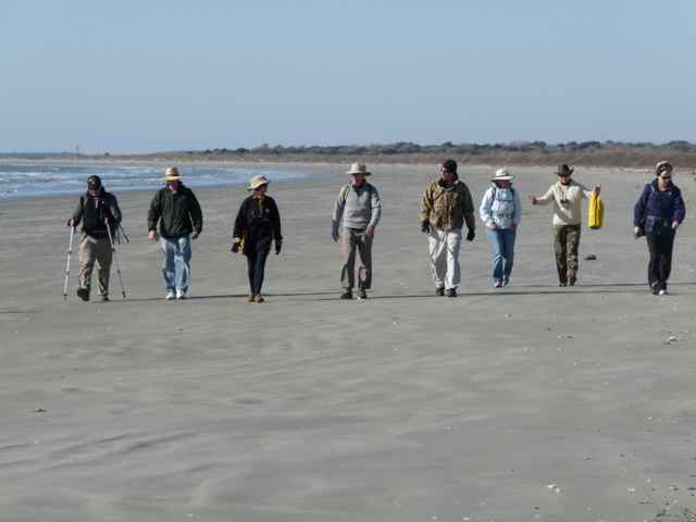
Photo credit: Tom Campbell
Faith had her eye out for a lettered olive, and before long a number of them were presented at her feet. I launched the shell of the day challenge to the group, and everyone all but conceded when Gay came upon an intact and blackened horse conch. The findings continued, and Tom came up with a loggerhead rib, an object that had to be left on the beach due to the species’ endangered status. 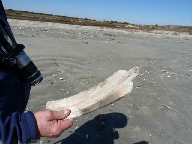
Photo credit: Tom Campbell
As guide for the group, I pointed out some of the bigger picture, particularly related to barrier island ecology. The south to north walk allowed for the viewing of excellently formed primary dunes that gradually degraded as we approached the Boneyard. I wanted to find an accessible viewing point for the shrub zone between primary dunes and maritime forest, and waited for the first “blowout” in the dunes for that entry. We entered the access, but beyond the zonal ecology in front of us, we had at our feet further entry into the loggerhead’s world. Many empty shells from the previous year’s nesting season littered the sand, perhaps from an undiscovered and predated nest. It was hands-on time for all, feeling the flexible shell material.
Discoveries and questions continued along the high tide line: infant whelks exposed from a whelk egg case, and the beautiful pentagonal symmetry of echinoderms. Our group passed the junction with the Beach Road and continued a steady pace to reach the Boneyard. Multiple logs provided seating for a break and an early lunch. I modeled in the sand both Bull and Cape Islands to discuss barrier island geology. 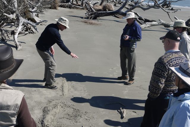
Photo credit: Faith McDavid
The setting allowed for shedding of layers from the early morning chill, and marveling at the beauty of this skeleton forest. Photographic opportunities were in abundance, including individual tree portraits. 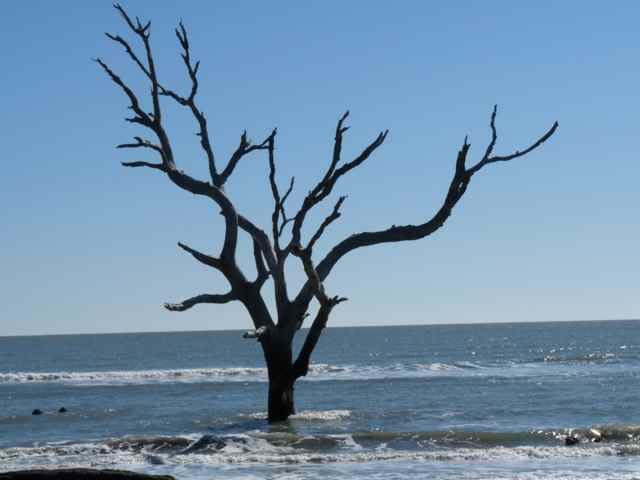
PHOTO CREDIT: TOM CAMPBELL
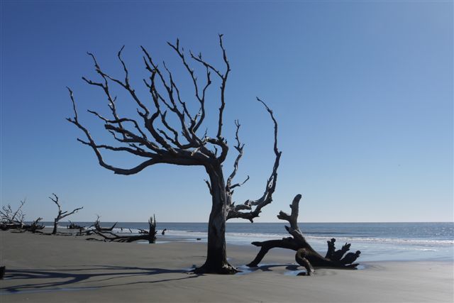
PHOTO CREDIT: FAITH MCDAVID
The famous surreal nature of the Boneyard captured the imaginations of all.
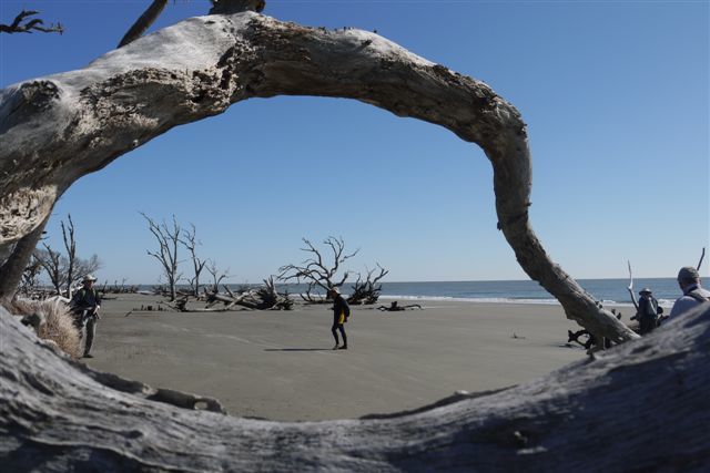
PHOTO CREDIT: FAITH MCDAVID
Forging on after lunch, we continued the rounding of this eastern point of the island, and came to a spot that stopped me in my tracks. The forest behind the Boneyard trees opened wide as part of a wetland (connected with Moccasin Pond), but at my feet a new slough (dry at this tide) showed the passage of tidal waters, and the island’s dynamic nature. This feature was all new to me – never seen. Beyond we left the Boneyard and started up the island’s eastern side toward the Northeast Point. We were halted again in our tracks by a perched adult bald eagle between the Jacks Creek dike and the beach, and all had a fine view of this beautiful bird. 
PHOTO CREDIT: TOM CAMPBELL
This was a common sight for Gay from the Olympic Peninsula – she has eagles at times in her yard. Dan from our group wondered with me about taking in so much with the eyes, and I realized the familiar for me was novel for many in our group.
I provided the group with a heads-up before the appearance of a tidal creek draining water from the marsh between the beach and the Jack’s Creek dike. Arriving there, no dry crossing was apparent, so I modeled wading across barefoot, while a few with waterproof shoes slogged over. Along here the view north opened up the northern end of the refuge. Our next stop was at the dike breach where a secondary dike now stems the tide, but as discussed it would be a matter of time before this section of the Jacks Creek dike would also be breached. We continued on toward the Northeast Point, and we picked out a “white sail” on the horizon that was in fact the Cape Romain lighthouse: binoculars revealed the second older lighthouse to its side. A second tidal creek, new since my last visit in the fall, also cut across the beach here and required a crossing. At the entrance through the dunes near the Northeast Point, we stopped to consider Bulls Bay, and the historic encounter in 1670 on the Point between Sewee Indians and English colonists.
We entered the road system, and took the walk down the east side of Jacks Creek on the dike. Spotting the first alligators of the day in the impoundment, the talk turned to the legendary alligator of the island “Alligatorzilla”. Mike from our group had grown up on the African continent, and when living in southern Sudan in his youth on a tributary of the Nile he was aware of the dangers of the Nile crocodiles. They grew to 25 feet, and were true man-eaters, notoriously taking women coming to fill water containers. Our route was planned to pass through Alligator Alley, and Pool #2 produced its usual group of basking reptiles.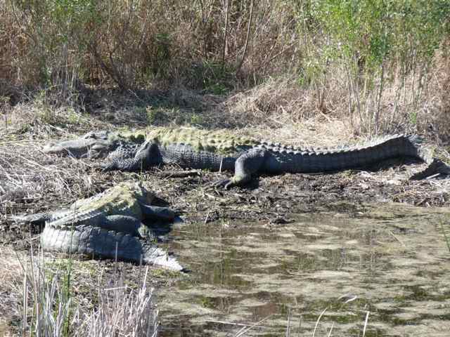
PHOTO CREDIT: TOM CAMPBELL
I was earlier concerned about making the 3PM ferry, but our walk even allowed pit stops at the facilities. Our group of thirteen had field tested this first time island hike, and it clearly was a route that would be repeated in the future.
We joined the passengers who came out at 10, and had a good crowd on the ferry. The ride was comfortable, and I knew many of our group would feel the miles on the ride back and the next day. We were treated to a beautiful scene along the ferry route. Making the turn to starboard into a creek, we passed an oyster rock populated with oyster catchers.
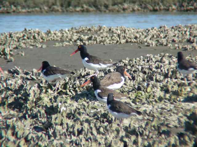
PHOTO CREDIT: TOM CAMPBELL
Those distinctive birds on their feeding ground, the creek and marsh in the background, and Bull Island further beyond, was a wonderful sight, and worth, from my perspective, the price of admission.
I knew the pristine atmosphere would darken after sunset into a crystal clear starry night. My motivation to view it came with a phone call from neighbors who were observing from their deck overlooking the ICW and refuge. I pulled on some extra clothes and drove to their home. I blindly walked around shrubs and trees to find the stairs to the deck, and began to get my night vision. My friend is a connoisseur of the night sky, and was already observing with a large scope, homemade to his exacting standards. I was guided by his skill, knowledge, and infinity with celestial objects: open clusters, nebulae, galaxies, and the paths to observe them. He rated it an “excellent” observing night, and the viewing of both new and familiar objects suspended above the marshes stretching out toward the Bay was a coda on a memorable day.
what a great trip for those new to the island and many things new to even those of us very familiar with it!
Absolutely great; always something new.
We had an outstanding trip, love the pictures posted, learned so much on this gorgeous day!!! Thanks to Bob
Thanks for helping to field test this new walk!
Nice Blog, I will have to check out Bull Island one weekend to see what I can find.
Lots to find – I keep looking.
Bull Island is one of my very favorite places and nothing is finer than to learn about it from someone who loves it even more than I do and knows it like the back of his hand! This was the second all-day Bull Island hike I’ve been on with Bob leading the way. (Chris Crolley did a great job of co-leading last year.) We had a perfect day for our expedition, and learned so much along the way! The beach was pristine and tide had washed up many beautiful shells that Bob identified for us. We learned about the maritime forest, beach erosion, the “bones” at Boneyard Beach, the history of Bull Island, the island’s elusive mascot, “Gatorzilla”, and much more, as we traversed the 11 miles of beach and natural wilderness. It was a fantastic day and I hope to go on many more of these hikes. I come back, feeling refreshed and with a better understanding and appreciation of the beauty and richness of this area. Thank you Bob, for sharing your knowledge and insights! Thank you Coastal Expeditions for giving us access to this “treasure” of an island!
Thanks for sharing those photos, Faith, and being a part of the group. Your appreciation of the island is evident. I agree it was a fantastic day – more of those are waiting.